In the past, Sa Kaeo was a major civilized community. Its long history had dated back since the Suwannaphum and Dvaravati Periods. The archeological sites of Khmer arts and stone inscriptions are the outstanding examples of this civilization.
Administratively, Sa Kaeo has been a district of Prachin Buri Province for a long period, and has officially been upgraded as a province since December 1, 1993.
Sa Kaeo is 245 kilometres, east of Bangkok, with the area about 7,195 square kilometres. Sa Kaeo is divided into 7 Amphoes (districts) and 2 King Amphoe (sub-districts): Amphoe Muang, Amphoe Watthana Nakhon, Amphoe Aranyaprathet, Amphoe Ta Phraya, Amphoe Khao Chakan, Amphoe Wang Nam Yen, Amphoe Khlong Hat, King Amphoe Khok Sung, and King Amphoe Wang Somboon.
Geographical Location
Sa Kaeo has its border facing Cambodia of approximately 165 kilometres. Generally, the area varies from plains to highlands. Highlands and mountains are in the north where Pang Sida National Park is located, while the south is covered with wavy plains and hills. Also, there are evergreen forests along the Chanthaburi mountain range. In the central, there are plains and hills, with Amphoe Watthana Nakhon as the highest area when compared to the other Amphoe Mueang in the west, and Amphoe Aranyaprathet in the east.
Boundary
North: Amphoe Khon Buri of Nakhon Ratchasima, and Amphoe Lahan Sai of Buri Ram
South: Amphoe Soi Dao of Chanthaburi
East: Cambodia
West: Amhoe Kabin Buri, Na Di of Prachin Buri, and Amphoe Sanam Chai Khet of Chachoengsao.
Distance from Amphoe Mueang to nearby districts :
- Amphoe Khao Chakan 19 kms.
- Amphoe Watthana Nakhon 38 kms.
- Amphoe Wang Nam Yen 50 kms.
- Amphoe Aranyaprathet 54 kms.
- Amphoe Khlong Hat 65 kms.
- Amphoe Ta Phraya 100 kms.
.
Distance from Sa Kaeo to nearby provinces :
Nakhon Ratchasima 184 kilometres
Prachin Buri 188 kilometres
Chanthaburi 258 kilometres
Chachoengsao 286 kilometres
Car
From Bangkok, use Phahonyothin Highway to Rangsit, use overpass to Highway No.305, pass Amphoe Ongkharak, Nakhon Nayok, after that use Highway No.33, pass Amphoe Kabin Buri to Sa Kaeo. Total distance is 214 kilometres.
From Bangkok, use Highway No.1 to Hin Kong, turn right to Highway No.33, pass Nakhon Nayok, Kabin Buri to Sa Kaeo. Total distance is 245 kilometres.
From Bangkok, use Highway No.304, pass Min Buri, Chachoengsao to Amphoe Phanom Sarakham, turn right at 35th kilometre, use Highway No. 304 to Kabin Buri. At 95th kilometre, turn right again to Highway No.33 to Sa Kaeo.
Bus
By bus :The Transport Co.,Ltd. provides bus services both ordinary and air-conditioned. Leave from Mo Chit Bus Terminal 2 everyday. For more details, please contact at Tel: 936-2852. There are two air-conditioned bus routes:
Route Bangkok Hin Kong Nakhon Nayok Sa Kaeo Aranyaprathet
First class bus leaves at 04:30 hrs., next bus at every 1 hour, last bus leaves 18:00 hrs. The fare is 135 Baht.
Second class bus leaves at 05:00 hrs., next bus at every 1 hour, last bus leaves 18:30 hrs. The fare is 118 Baht.
Route Bangkok Ongkharak Nakhon Nayok - Sa Kaeo Aranyaprathet
First class bus leaves at 04:45 hrs., next bus at every 1 hour, last bus leaves 18:30 hrs. The fare is 118 Baht.
Second class bus leaves at 05:00 hrs., next bus at every 1 hour, last bus leaves 18:45 hrs. The fare is 95 Baht.
Train
By rail: State Railways of Thailand provides service from Hua Lamphong Station in Bangkok to Sa Kaeo and Aranyaprathet twice everyday, leaving at 05:55 and 13:05 hrs. The fare is 48 Baht / person. For more details, please contact Travel Service Unit at Tel: 1690, 0 2223 7010, 0 2223 7020
Ban Khlong Luek Border Market (Rong Kluea Market)
The Aranyaprathet international immigration control is 500 metres from Talat Rong Kluea. Passport bearers can pass and travel to the third country with approved visa from the Cambodian Embassy or Consulate. This is the shortest way to travel in Cambodia. There are vans, pick-up trucks for rental service to Poipet, Siam Riap
Tracing its origins to the end of the war in Cambodia, this market is renowned for selling secondhand brand name garments at very cheap prices. Originally, brand name clothes in good condition were donated to Cambodian people through the United Nations. Cambodian people brought the clothes to sell at the Thai border. At present, there are no more donated clothes. Nevertheless, the market is still popular because of its former business. These days, goods which are on sale there are exported from Korea, Japan, and Hong Kong. They are bought to be resold at Rong Kluea Market, which is the largest source of secondhand clothes from abroad, while shoes, purses, winter sweaters and jackets will be sorted into containers and shipped to Laem Chabang Sea Port, Chonburi Province. Jeans and other pants are shipped via Cambodias’ Kampongsom Sea Port. Some expensive brand name jeans may be resotred and sent to be sold in Japan.
When goods arrive at Rong Kluea Market, merchants will bring their workers to sort the clothes according to their condition. Then they will specify prices, and clean and fix the garments. Some clothes are restored so expertly that they look good as new; in fact amateur merchants and first-time buyers may not know that the clothes are secondhand. Shop owners at Rong Kluea Market are mostly Chinese-Cambodian, as well as Vietnamese emigrants from the Cambodian provinces of Phnom Penh, Siemrat and Phra Tabong, while Thais make up only 10 % of the total. The border is open from 7 am – 8 pm. Every day between 7 and 8 am, more than 2,000 Cambodians cross the border. They can be categorized into 3 groups: the first group consists of workers without bags, who have waited since dawn and rush to open shops for their owners in the market; the second group is made up of merchants who carry their goods by hand, on their shoulders or on their heads; the third group comprises porters who earn their living carrying goods in the market, as well as baggage for tourists travelling to Angkor Wat – Angkor Thom.
When shopping there, visitors are advised to be very thorough and to carefully examine all goods. Since real brand name goods are mixed in with counterfeit ones, keen and lucky eyes may get a pair of 1,500-2,000 baht jeans for just 700 – 950 baht. On the contrary, amateur shoppers often purchase counterfeit goods at a high price.
Pang Sida National Park
Covering the area in Amphoe Muang, Amphoe Wattana Nakhon, Amphoe Ta Phraya of Sa Kaeo and Amphoe Na Di of Prachin Buri, the Park occupies an area of 844 square kilometres or 527,500 Rai. It has been declared a national park on February 24. 1982. The topography of the area consists of complex highlands with various and diversified forests, and an abundant of wild and rare animals. The area is the origin of many creeks which form the Bang Pakong River. The major attractions in the park are:
Namtok Pang Sida (Pang Sida Waterfall) The waterfall is approximately 800 metres from the park office. With a large pond below the 10 metre waterfall, the surroundings are very shady, with much water during the rainy season.
Namtok Pha Takhian About 3 kilometres from the park office, and about 2.5 kilometres from Namtok Pang Sida, the 10 metre waterfall can be reached by 2 trekking trails which are suitable for nature study.
Tha Krabak Reservoir Built under H.M.the Kings project to improve the irrigation, the reservoir is located in Moo 7 Tambon Tha Yaek, about 32 kilometres from town. It is a dam that is 17.50 metres high, and 720 metres long, surrounded by various kinds of forests. Its spectacular views are most suitable for relaxation.
Tha Krabak Waterfall This waterfall is near the reservoir, with 3 levels which are 400-500 metres apart.Khwae Makha Waterfall Khwae Makha Waterfall is about 6 kilometres from the 40th kilometre. It is approximately 70 metres high. The trail is suitable for trekking. Nearby, there are various waterfalls located at different distances from Kwae Maka Waterfall. These waterfalls are Rak Sai Yoi Waterfall (500 metres), Lan Hin Yai Waterfall (1.5 kilometres), Suan Man and Suan Thong Waterfalls (3 kilometres), Man Thara Waterfall ( 4 kilometres ). To discover these waterfalls, you might need to spend 2-3 days because they are located deep into the forest.
Tham Khang Khao Waterfall The waterfall can be reached by a walking distance of about 10 kilometres from the 22th kilometre. There are many bats living in this area.
View Point Situated in the huge valley at the 25th and 35th kilometres, sunrise and sunset can be watched here at this view point.
Fresh Water Crocodile From the park office about 5 kilometres, to Moo Ban Khlong Phak Khom- Thung Pho for about 50 kilometres, this source in Huai Nam Yen Forest, has been surveyed since 1991.
Accommodation The National Park has house renting service at 500-600 Baht per night. Tent area is also available at the rate of 5 Baht/person/night. For more details, contact Pang Sida National Park, P.O.Box 55, Tambon Tha Yaek, Amphoe Muang, Sa Kaeo 27000, Tel: 0 3755 6500,0 3724 3775 Fax: 0 3724 3774 or National Park Div., Dept. of Forestry, Bangkhen, Bangkok at Tel: 0 2562 0760
Traveling By Car: From town, heading north by using Highway No.3462 about 27 kilometres, the National Park is on the right. If tourists need to travel by public transportation, they can use mini-cab route Sa Kaeo Ban Khlong Nam Khiao for about 27 kilometres to the park office. Another route is by train (Bangkok Aranyaprathet), getting off at Sa Kaeo Station, then use mini-cab as mentioned above.
Khao Chakan
This mountain is about 17 kilometres from the city, on highway no.317 (Sa Kaeo Chanthaburi) between 131st-132nd kilometres. The highest point is about 240 metres. There are 72 interesting caves. On the foot of the mount, is the location of Wat Khao Chakan and a botanical garden. There are stairs to the top which is a good viewpoint.
Prasat Khao Lon
This temple is on Khao lon in Ban Charoen Suk, Tambon Thappharat. The architectural style of this site is similar to that of Prasat Khao Noi. There were four towers (prang). However, only the central one is still existed. To the northeastern part of the temple are two large ponds which are connected to the temple by an ancient roadway. Traveling to this temple is by using highway No.3068 (Ta Phraya Buri Ram), and then turning left to Ban Charoen Suk. It is about 28 kilometres from Ta Phraya.
Chong Klam Bon Wildlife Breeding Station
Located at Tambon Nong Mak Fai, this site has the area of approximately 430 Rai. The accessibility to this area is by using the same route to Pang Sida National Park, pass Tha Krabak Reservoir for about 500 metres, turn left for about 3 kilometres. Under Wildlife Sanctuary Bureau of Forestry Department, this sanctuary has been established in 1983, initiated by H.M.the Queen Sirikit to conserve rare and wild animals, such as wild birds and mammals. This sanctuary also conducts studies and researches on wild animals, and disseminates information, and knowledge in wildlife.
Wat Anu Banphot
This temple is located in Moo 2, Tambon Ban Mai Nong Sai. It is on Thana Withi Road (to Amphoe Ta Phraya) about 1 kilometre detour from Suwannason Road. It was built in 1925 during the reign of King Rama VI. The highlight of this temple is the beautiful chapel (ubosoth) which houses the imitation of Lord Buddha's footprint made from brass.
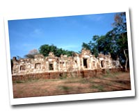
Prasat Khao Noi
This site is situated in Wat Khao Noi Si Chomphu, Tambon Khlong Nam Sai, which is 12 kilometres to the south of the city. This ancient venue is on the 80 metre hill. With the stairs of 254 steps, this site is composed of three towers (prang). However, only the central one has been remained. It has been registered in year 1935 by the Department of Fine Arts as the national ancient site. Some sandstone lintels and statues were found, and they are now displayed at the Prachin Buri National Museum. |
Phra Siam Thewathirat
Located in front of Aranyaprathet Police Station, with the height of 1.29 metres, this is the imitation of the real Phra Siam Thewathirat, built by Phra Uthai Thammathari in 1975. The people of Aranyaprathet constructed a throne with four posts to house the image on December 20, 1985. This sacred image has been worshipped by the people of Aranyaprathet and nearby provinces.
Aranyaprathet Victory Gate
Situated on the Thailand Cambodia border at Ban Khlong Luek, Tambon Tha Kham, the gate was constructed in 1939. The shape of the gate consists of two octagonal 15 metre towers, with the base used as the guarding area. These towers were destroyed by war. In 1959, the left tower was reconstructed in the same shape to commemorate the dead and injured soldiers. The right tower was altered to a huge marble heart-shaped boundary stone facing Cambodia, with the Garuda (mythical bird-man) image on top, and the name Thailand below.
Tham Hat Sai Kaeo
Situated at Ban Khao Lueam, Amphoe Khlong Had, this small cave is part of the same mountain range as Tham Phet Pho Thong. Tham Had Sai Kaeo offers a 25 m cliff, where rappelling activities are offered. The cave contains impressive stalagmites and stalactites, in striking shapes and figures which visitors will enjoy. Besides, its sandstone ceiling and walls glitter magnificently in reflected light. The cave presents great photo opportunites.
For further information, contact Tambon Khlong Had Administration Organization, tel. 0 3751 2142, 0 8 9936 3880, 08 6101 1539.
Getting there: By car – Take Hwy 317 From Sa Kaeo Town and turn left onto Hwy 3067. Continue past Amphoe Khlong Had District Office. Drive for another 4 km, then turn left and continue for 3 km. Visitors will arrive at Tham Phet Pho Thong and Tham Had Sai Kaeo.
Tham Phet Pho Thong
Situated at Ban Khao Lueam in Amphoe Khlong Had, visitors will enjoy trekking to the cave through Chan Pha Forest, which is preserved by the villagers. Throughout the year, the cave is well ventilated with natural breezes and fresh mountain air. The inside of the cave is separated into 4 zones:
Zone 1 – Entering the cave mouth, visitors will be fascinated by a spacious oval area, naturally decorated with creamy white rocks. Zone 2 – Descend from the tunnel to a large hall, where the sun shines through from the north. The area is pleasant with good air ventilation, and a cool breeze.
Zone 3 – Walk to ‘the pearl hall adorned with diamonds’. This spacious hall is the cave’s highlight, where stalactites and stalagmites form a pearly, oval Chedi decorated with glittering sand. Throughout the cave, the walls and ceiling are decorated with golden Bo leaf–like patterns, caused by rust formation as water trickles down through the rock. This cave is amazingly beautiful and interesting.
Zone 4 – This zone is dubbed ‘the castle gate of the cave’. Smooth creamy stones are found at the cave mouth. In addition, there is an interesting stalactite and stalagmite formation which looks like a Buddha statue.
For further information, contact Tambon Khlong Had Administration Office, tel. 0 3751 2142, 08 9936 3880, 08 6101 1539.
Sa Kaeo - Sa Khwan
These two ponds are located in Tambon Sa Kaeo on the western side of town. Before approaching the city, turn right at 246th kilometre. It is believed that these two ponds contain sacred water once used for the coronation ceremony. The name of the province (Sa Kaeo) had been derived from this venue, whereby Somdej Chaophraya Maha Kasatsuk (King Rama I later) went to fight with the Cambodians, and stopped at this site to use sacred water to swear for the fighting courage.
La-lu
Located at Ban Khlong Yang, Tambon Thap Rat, this venue is a large area about 800 acres with many earth pillars in various shapes like the ones in Phrae Province. They are indeed an amazingly beautiful site of nature wonder. At Ban Khlong Yang, home-stay trip is available.
Ta Phraya National Park
The Ta Phraya National Park was declared a National Park in 1996. The park covers an area of 371,250 rai (equivalent to 594 sq.km.). The area surrounding the park and the boundary of the park form a straight line connecting Pangsida National Park from the west to Cambodia in the east. In the north, the park is connected to Tab Lan National Park and Burirum province. This is also where the administrative offices of the park are located.
The general landscape of the park is a plain area surrounded by hilly tracks. The major hill track of the park is the Bantad hill track, which stretches eastward as a natural boundary line separating Thailand and Cambodia. Hillside areas a botanical plain, with a tropical forest in pristine condition made up of many tree varieties.
Huai Yang reservoir: is a large reservoir located in Tambon Thub Rach, Amphoe Tha Pha Ya , Sa Kaeo Province. There is wonderful scenery especially in the productive semi-evergreen forest around the reservoir. Many people go to recreate in the area all-year round. Travel on Highway No. 3189 to get there.
The park is a major water source, and numerous streams and rivers have their origins here. It is also home to various kinds of animals such as Gaur, deer, wild pig, Antelope, and more than 300 different species of birds.
Ta Phraya National Park can be reached by driving along National Highway No.33, passing through Sa Kaeo province and Wattana Nakhon district. After reaching Aranyaprathet district, turn left onto National Highway No.27. The road to the park is a 13-km-long non-surfaced road. 4WD vehicles are recommended.
Those interested in studying nature, please contact the office of Ta Phraya National Park directly at P.O. Box 9 None Din Daeng, Amphoe None Din Daeng , Buriram 31260 Tel. 0 3755 6667, 0 4561 9214 Fax: 0 3724 6056 (please contact the office 15 days in advance)
สระแก้ว : ข้อมูลทั่วไป
ชายแดนเบื้องบูรพา ป่างาม น้ำตกสวย มากด้วยรอยอารยธรรมโบราณ ย่านการค้าไทย - เขมร
สระแก้ว เป็นจังหวัดชายแดนด้านตะวันออก อยู่ห่างจากกรุงเทพฯ ประมาณ 245 กิโลเมตร ในอดีตเคยเป็นชุมชนสำคัญที่มีความเจริญรุ่งเรืองมาก่อน มีประวัติศาสตร์ความเป็นมายาวนานตั้งแต่สมัยอาณาจักรสุวรรณภูมิ และอาณาจักรทวาราวดี โดยจะเห็นได้จากกลุ่มปราสาทโบราณที่มีมากมายอยู่ทั่วจังหวัดและโบราณวัตถุที่หลงเหลือ บอกเล่าเรื่องราวประวัติศาสตร์ ความรุ่งเรืองของแผ่นดินในอดีต ให้แก่คนรุ่นหลัง
นอกจากแหล่งโบราณสถานที่น่าศึกษาทางประวัติศาสตร์ จังหวัดสระแก้วยังมีทรัพยากรธรรมชาติอันอุดมสมบูรณ์ เช่น อุทยานแห่งชาติปางสีดา และอุทยานแห่งชาติตาพระยา นอกจากนี้ยังมีแท่งดินประติมากรรมทางธรรมชาติอย่าง "ละลุ" ที่มีรูปลักษณะแปลกตา
สุดชายแดนอรัญประเทศสระแก้วเป็นประตูบานใหญ่ที่เปิดไปสู่ประเทศกัมพูชา เชื่อมการคมนาคมและการท่องเที่ยวระหว่างประเทศให้เป็นเส้นทางเดียวกัน มีตลาดโรงเกลือที่เต็มไปด้วยของราคาถูกและสินค้ามือสองจากนานาประเทศเพื่อนบ้าน
สระแก้วเป็นจังหวัดที่74 ของประเทศไทย เดิมมีฐานะเป็นเมืองบริวารของปราจีนบุรี (เมืองประจิมในสมัยโบราณ) และในปี พ.ศ.2476 เมื่อมีการยกเลิกระบบเทศาภิบาล ปราจีนบุรีได้รับการยกฐานะให้เป็นจังหวัด สระแก้วจึงกลายเป็นอำเภอหนึ่งของจังหวัดปราจีนบุรี ต่อมาได้แยกตัวออกมาจากปราจีนบุรี และได้รับการประกาศให้เป็นจังหวัดอย่างเป็นทางการในวันที่ 1 ธันวาคม พ.ศ. 2536
จังหวัดสระแก้วมีประวัติความเป็นมาที่ยาวนานนับ 4,000 ปี ตั้งแต่ยุคหินใหม่-ยุคโลหะ โดยมีการค้นพบวัตถุโบราณที่บ้านโคกมะกอก ตำบลเขาสิบ อำเภอเขาฉกรรจ์ ในยุคต่อมาก็มีการค้นพบโบราณวัตถุอีก เช่น ที่อำเภออรัญประเทศและอำเภอตาพระยา แสดงหลักฐานว่าสระแก้วเคยเป็นชุมชนสำคัญที่มีความเจริญรุ่งเรืองในยุคเจนละ- ทวารวดี มีอารยธรรมและวัฒนธรรมเป็นของตนเอง มีกษัตริย์หรือผู้ครองเมืองที่นับถือศาสนาฮินดูลัทธิไศวนิกายและไวษณพนิกาย ดังจะเห็นได้จากโบราณสถานและจารึกรูปอักษรปัลลวะต่างๆ ปรากฏที่ปราสาทเขาน้อย เขารัง และช่องสระแจง เป็นต้น โดยเฉพาะจารึกรูปอักษรปัลลวะที่ปรากฏในบริเวณปราสาทเขาน้อยเขตอรัญประเทศซึ่งถือกันว่าเป็นหลักฐานบันทึกศักราชที่เก่าแก่ที่สุดในกลุ่มจารึกรุ่นแรกที่พบในประเทศไทย สร้างขึ้นราวปีพุทธศักราช 1180
นอกจากนี้ยังค้นพบหลักฐานความเจริญของอารยธรรมระหว่างพุทธศตวรรษที่ 15-16 ในแถบนี้อย่างมากมาย มีทั้งปราสาทอิฐ ปราสาทหิน เตาเผา เครื่องถ้วย และคูเมืองโบราณที่ยังเหลือร่องรอยปรากฏในปัจจุบัน เช่น จารึกพบที่ปราสาทสด๊กก๊อกธมอีก 2 หลัก ซึ่งในระหว่างพุทธศตวรรษที่ 15 ปราสาทสด๊กก๊อกธมได้ถูกสร้างขึ้นเพื่อเป็นเทวสถานของพระศิวะ ดังข้อความในจารึกสด๊กก๊อกธมหลักที่ 1 ได้กล่าวถึงว่าในปีพุทธศักราช 1480 พระเจ้าชัยวรมันที่ 4 โปรดให้นำศิลาจารึกมาปักไว้ที่ปราสาทสด๊กก๊อกธม เพื่อประกาศห้ามเรียกข้าของเทวสถานแห่งนี้ไปใช้ในกิจการอื่น แต่ให้ข้าของเทวสถานได้บำรุงรักษาและบูชาพระศิวลึงค์หรือรูปเคารพ ซึ่งประดิษฐานอยู่ ณ เทวสถานสด๊กก๊อกธมนี้ตลอดไป ส่วนจารึกอีกหลักหนึ่งก็ได้กล่าวสรรเสริญพระเจ้าอาทิตยวรมันที่ 2 ซึ่งได้ทรงบูรณะโบราณสถานแห่งนี้จนสำเร็จพร้อมจารึกที่เกี่ยวกับอารยธรรมและศาสนาเป็นต้น จากจารึกและโบราณสถานที่พบนี้สามารถบ่งบอกให้เราทราบถึงระบบการปกครองของอาณาจักรขอมโบราณบนผืนแผ่นดินสระแก้วแห่งนี้ เปรียบเสมือนมรดกทางภูมิปัญญาของบรรพชนที่มีคุณค่าเป็นคุณประโยชน์ต่อการศึกษายิ่ง
จังหวัดสระแก้วมีพื้นที่ทั้งสิ้นประมาณ 7,195 ตารางกิโลเมตร หรือ 4,496,961 ไร่ แบ่งการปกครองออกเป็น 9 อำเภอได้แก่ อำเภอเมือง อำเภอวัฒนานคร อำเภออรัญประเทศ อำเภอตาพระยา อำเภอเขาฉกรรจ์ อำเภอวังน้ำเย็น อำเภอคลองหาด อำเภอโคกสูง และอำเภอวังสมบูรณ์
อาณาเขต
ทิศเหนือ ติดต่อกับอำเภอครบุรี จังหวัดนครราชสีมา และอำเภอละหานทราย จังหวัดบุรีรัมย์
ทิศใต้ ติดต่อกับอำเภอสอยดาว จังหวัดจันทบุรี
ทิศตะวันออก ติดต่อกับราชอาณาจักรกัมพูชา
ทิศตะวันตก ติดต่อกับอำเภอกบินทร์บุรี อำเภอนาดี จังหวัดปราจีนบุรี และอำเภอสนามชัยเขต จังหวัดฉะเชิงเทรา
หมายเลขโทรศัพท์ที่สำคัญ
- ศาลากลางจังหวัดสระแก้ว โทร. 0 3742 5127
- สำนักงานจังหวัดสระแก้ว โทร. 0 3742 5125
- ที่ว่าการอำเภออรัญประเทศ โทร. 0 3723 1016
- ด่านตรวจคนเข้าเมืองอรัญประเทศ โทร. 0 3723 1131
- สำนักงานประชาสัมพันธ์จังหวัดสระแก้ว โทร. 0 3742 5066-7
- สถานีเดินรถโดยสารประจำทาง โทร. 0 3724 2362
- สถานีตำรวจภูธร อ.ตาพระยา โทร. 0 3726 9111
- สถานีตำรวจภูธร อ.เมือง โทร. 0 3724 1017
- สถานีตำรวจภูธร อ.วัฒนานคร โทร. 0 3726 1507-8
- สถานีตำรวจภูธร อ.วังน้ำเย็น โทร. 0 3725 1111
- สถานีตำรวจภูธร อ.อรัญประเทศ โทร. 0 3723 1203
- โรงพยาบาลวัฒนานคร โทร. 0 3726 1772
- โรงพยาบาลอรัญประเทศ โทร. 0 3723 3075-9
- โรงพยาบาลสมเด็จพระยุพราชสระแก้ว โทร. 0 3724 2532, 0 3724 1011-2, โทร. 0 3724 3018-20
- โรงพยาบาลตาพระยา โทร. 0 3726 9009, 0 3751 0252
- โรงพยาบาลวังน้ำเย็น โทร. 0 3725 1108-9
- โรงพยาบาลคลองหาด โทร. 0 3751 2258-61
- โรงพยาบาลเขาฉกรรจ์ โทร. 0 3751 1272
Link ที่น่าสนใจ
สำนักงานตรวจคนเข้าเมืองจังหวัดสระแก้ว
http://www.aranimmigration.com
คู่มือไหว้พระศักดิ์สิทธิ์แดนธรรมะ 66 วัด
http://www.tat8.com/thai/news/greet.htm
สำนักงานจังหวัดสระแก้ว
http://www.sakaeo.go.th
ข้อมูลตำบลและสินค้าหนึ่งตำบลหนึ่งผลิตภัณฑ์
http://www.thaitambon.com
ข้อมูลอำเภอคลองหาด
http://www.klonghad.com
สระแก้ว : ข้อมูลการเดินทาง
การเดินทางจากสระแก้วไปยังจังหวัดใกล้เคียง
| นครราชสีมา |
184 กิโลเมตร |
| ปราจีนบุรี |
188 กิโลเมตร |
| จันทบุรี |
258 กิโลเมตร |
| ฉะเชิงเทรา |
286 กิโลเมตร |
รถยนต์
การเดินทางไปจังหวัดสระแก้วสามารถใช้เส้นทางได้ 4 เส้นทาง ได้แก่
1. จากกรุงเทพฯ ใช้เส้นทางสายพหลโยธินมาถึงรังสิต แล้วให้ชิดซ้ายโดยใช้สะพานวงแหวนข้ามมาลงที่เส้นทางหมายเลข 305 ผ่านอำเภอองครักษ์ จังหวัดนครนายก จากนั้นเข้าเส้นทางหลวงหมายเลข 33 ผ่านอำเภอกบินทร์บุรี ไปจนถึงจังหวัดสระแก้ว ระยะทางประมาณ 214 กิโลเมตร
2. จากกรุงเทพฯ ใช้เส้นทางหลวงหมายเลข 1 แล้วเลี้ยวขวาที่แยกหินกองไปตามทางหลวงห&# |