Well worth a visit is the huge Erawan Cave, Full of beautiful stalagmites and stalacitites. A very long stairway leads up to the cavern, where a large Buddha sits at the entrance.
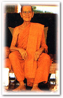
Wat Tham Klong Phen, a tranquil forest monastery outside of town, is revered as the home of the famous meditation monk. Luang Phu Khao Analayo. A museum in the compound is dedicated to the monk. A beautiful nature reserve is found at Phu Kao Phupan Kham National Park covering 320 square kilometres, including a large lake formed by Ubon Ratana Dam, which is a popular fishing area.
Car
From Bangkok, take Highway No. 1 to Saraburi and Highway No. 2 to Udon Thani via Nakhon Ratchasima and Khon Kaen, then take Highway No. 210 to Nong Bua Lam Phu, a total distance of 608 kilometres.
Bus
Buses depart from Bangkok's Mochit 2 Bus Terminal to Nong Bua Lam Phu every day. Contact Transport Co.Ltd at Tel: 0 2936 2852-66 or visit www.transport.co.th for more information
Rail
There is no direct train from Bangkok to Nong Bua Lam Phu. Visitors can take a train to Udon Thani and continue the journey by bus to Nong Bua Lam Phu. Call 1690, 0 2223 7010-20 for more information.
Air
Visitors can fly from Bangkok to Udon Thani and then continue the trip by bus to Nong Bua Lam Phu. Call Thai Airways, Tel: 1566, 0 2280 0060, 0 2628 2000 for more information.
Distances from Amphoe Mueang to Other Districts
Na Klang
Si Bun Rueang
Non Sang
Na Wang
Suwannakkhuha |
30
33
42
42
65 |
kms.
kms.
kms.
kms.
kms. |
Tham Erawan
This cave is 45 kilometres from town on Highway No. 210 (Nong Bua Lam Phu-Loei) past Na Klang and Na Wang to Km. 13, then a right for 2 kilometres and up about 600 steps by foot up the mountain. At the mouth of the cave is a large Buddha image clearly visible from a distance. Inside the cave is a large space with lovely stalactites and stalagmites. The cave is the origin of local folklore called Nang Phom Hom.
Wat Tham Klong Phen
This temple is at the foot of Phu Phan mountain, 13 kilometres from town on Highway No. 210 (Nong Bua Lam Phu-Udon Thani), then 2 kilometres on the right. The area was once the site of an ancient Khmer temple that later became deserted until 1958 when Phra Achan Luang Pu Khao Analyo turned it into a meditation centre until his death in 1983. A museum displays his wax figure as well as his personal items. The temple is very peaceful with a large area and covered with shady trees and natural rock formations. It is most suitable for meditation.
Pottery-making at Ban Khong Sawan
Pottery-making at Ban Khong Sawan
This pottery village is 17 kilometres from town on the way to Udon Thani. The villagers here migrated from Ban Wang Thua, Amphoe Nam Phong, Khon Kaen. The village specialty is making pottery with designs similar to that in Ban Chiang and using traditional techniques.
This pottery village is 17 kilometres from town on the way to Udon Thani. The villagers here migrated from Ban Wang Thua, Amphoe Nam Phong, Khon Kaen. The village specialty is making pottery with designs similar to that in Ban Chiang and using traditional techniques.
Namtok Thao To Forest Park
This is 3 kilometres from town on the way to Udon Thani. A road here runs through a mountain. There is a small waterfall covered with large, shady trees. Nearby is the Chao Pu Lup Shrine which is worshipped by the locals. Cars passing the shrine usually honk their horn as a sign of respect and for good luck on their journey.
Million-year-old shell fossils
Million-year-old shell fossils
This archaeological site is approximately 10 kilometres from town on the Nong Bua Lam Phu-Udon Thani road. Mollusk fossils have been found here buried in sandstone. The fossils are about 140 million years old.
This archaeological site is approximately 10 kilometres from town on the Nong Bua Lam Phu-Udon Thani road. Mollusk fossils have been found here buried in sandstone. The fossils are about 140 million years old.
King Naresuan the Great shrine
This shrine is in the public park opposite the provincial hall. It commemorates the time when King Naresuan the Great of the Ayutthaya period led his troops to Nong Bua Lam Phu in 1574 on the way to helping the king of Hongsawadi fight the city of Si Sattana Khanahut.
Wooden Ubosoth of Wat Chaoreon Songtham
Located in Ban Don Por, Tambon Nong Bua Tai, the wooden chapel or Ubosoth has compact size in rectangular shape. High roof creates good air ventilation. The ubosoth has delicate carving on the roof, and gable with neatly carved garuda. How to get there: The ubosoth is 30 kilometres from Nongbua Lampu City, motorist can use Nongbua Lampu-Sangsian Road.
None Don Klang Archeological Site (Ban Kud Kwang Soy)
None Don Klang Archeological Site (Ban Kud Kwang Soy). Situated in Ban Kud Kwang Soy, Soi Santisuk, Tambon Ban Thin, east of Phu Khao Mount, it is an archeological site. Pre-historical artifacts found here include terra cottage similar to Ban Chiang Culture, human’s skeleton, bronze and stone bracelet, glass beat, sandstone mold for bronze axe, steel tool and etc. Some artifacts are kept at National Museum Khon Kaen, the remaining are displayed in the village’s museum.
How to get there. Use highway 2146 (Nongbua Lampu-None Sang) for 36 kilometres and turn right at Ban Nong Waeng and keep going for 5 kilometres.
Wat Tham Suwannakhuha
This temple is around 5 kilometres from the district office. A Buddha image built by Phra Chaiyachetthathirat of Vientiane in 1555 is here. It was built at the same time as Phra Chao Ong Tu and Luang Pho Phra Sai in Nong Khai.
Phu Pha Ya Archaeological Site
This is north of Ban Na Charoen in Tambon Dong Mafai. In Wat Phu Pha Ya Thammasathit are prehistoric drawings on a mountain. The drawings are of red paint and depict geometric figures, animals, palm prints, and humans. They date from 2,000-3,000 years ago.
Phu Kao-Phu Phan Kham National Park
This park covers 322 square kilometres. The park headquarters is near the lake at Ubonrat Dam at the foot of Phu Phan mountain in Non Sang. From Nong Bua Lam Phu, take Highway No. 2146 (Nong Bua Lam Phu-Non Sang) for about 40 kilometres to the intersection at Ban Sok Chan, then a left onto the Ban Sok Chan-Ubonrat Dam road for about 14 kilometres to the park office. From Khon Kaen, there is a 7-kilometre road from the dam to the park office.
Phu Phan Kham is a part of Phu Phan mountain range. Stretching north to south, it divides Nong Bua Lam Phu and Khon Kaen. The view of the lake at Ubonrat Dam is magnificent. Tourists frequently overnight near the park office beside the lake.
Phu Kao consists of 9 mountains. The most interesting spots branch out eastward from the Non Sang-Nong Bua Lam Phu road. On the laterite road to Ban Kut Bak are observation points, prehistoric drawings at Mum cave, Wat Phra Phutthabat Phu Kao, rock recesses shaped like human and dog footprints that are the source of local folklore, dinosaur footprints on a rock plateau near a stream, and Tat Fa waterfall. A park official is required as guide into Phu Kao.
Phu Kao-Phu Phan Kham National Park
The park acquires a total area of 320 square kilometres or 201,250 rai, in Amphoe Ubolratana and Amphoe Non Sang of Nong Bua Lam Phu province. Most area is deciduous dipterocarp forest, which always changes its hue by early November. The national park headquarters at Phu Phan Kham by the lake has a picturesque sunset view. Camping ground is available. The attractions in the park include traces of a pre-historical community of the same period as Ban Chiang such as cave paintings and carvings footprints of dinosaurs that are presumed to be the same species as those found in Phu Wiang.
How to get there: from Khon Kaen, head for Ubolratana Dam until reaching Ubolratana Market 50 kilometres away. Then go via the Ubolratana-Non Sang Road, the park headquarters is 6 kilometres away. Motorists can also reach the park through the Udon Thani-Loei Road, then go through Amphoe Non Sang and get onto the Sok Chan-Ubolratana Dam Road. Bus on the route Ubolratana Dam-Non Sang also reach the park. The buses leave from Ubolratana Market.
Huay Rai Reservoir
The medium sized reservoir is situated in Ban Srakaeo, Moo 6, Tambon Dongsawan. With clear water, the reservoir is quite scenic. From November to February, Sunn hemp plantation will paint the area in bright yellow. Tourist can enjoy cruising on motored raft which can control direction, unique vehicle of the reservoir. Restaurants on the raft are available.
Wat Santitham Banpot or Wat Pa Phu Noi
Besides offering very nice place for practicing meditation, the temple houses Buddha footprint and 8 groups of stone leaves setting in 8 directions. Each group comprises 4 stone leaves, some feature carving in Bhotisattva and pagoda’s crest. These leaves are probably places around Khmer shrine like those at Wat Sri Muang Koon. How to get there: The temple is 30 kilometres from Nonbua Lampu City, motorist can use highway 210 (Nongbua Lampu-Loei) and turn left at Amphoe Na Klang. It is 1.5 kilometes away.
Tham Pha Wiang
The cave is situated in Moo 9 Ban Pha Wiang, Tambon Na Kae among picturesque mountain range called Phu Pha Wiang. The cave and around is territory of Wat Tham Pha Wiang. Tham Pha Wiang is naturally beautiful with rock formation and stalagmites. There are also many caves in the area such as Tham Pha Klang, Tham Thammas, Tham Pratoon, Tham Kok Nuayai, Tham Kangkao. How to get there: The cave is 45 kilometres from Nongbua Lampu City, motorist can use highway 210 (Nongbua Lampu-Loei).
Namtok Huay To Botanical Park
Namtok Huay To Botanical Park. Sitauated on highway 210 (Nongbua Lampu-Udon Thani) some 3 kilometres from Nongbua Lampu City, the shady park is a nice place for picnic. The secreted shrine of Pu Loop is located nearby.
Phra Wor Phra Ta City Pillar Shrine
Phra Wor Phra Ta City Pillar Shrine. Located just 100 metres from highway 210 (Nongbua Lampu-Udon Thani), the city pillar shrine is built to honor Phra Wor and Phra Ta who had established the city. The first stone of this city pillar shrine was laid on November 21, 1975. It was completed and opened on February 28, 1976.
หนองบัวลำภู : ข้อมูลทั่วไป
ศาลสมเด็จพระนเรศวรมหาราช อุทยานแห่งชาติภูเก้าภูพานคำ แผ่นดินธรรมหลวงปู่ขาว
เด่นสกาวถ้ำเอราวัณ นครเขื่อนขันธ์กาบแก้วบัวบาน
หนองบัวลำภู เป็นเมืองโบราณที่มีประวัติยาวนานไม่น้อยกว่า 900 ปี เดิมเป็นดินแดนที่ขึ้นต่อกรุงศรีสัตตนาคนหุต(เวียงจันทน์) มีชื่อว่า“เมืองหนองบัวลุ่มภู นครเขื่อนขันธ์ กาบแก้วบัวบาน” หนองบัวลำภู ได้รับแต่งตั้งเป็นจังหวัดอย่างเป็นทางการในวันที่ 1 ธันวาคม พ.ศ. 2536 เดิมเป็นอำเภอหนึ่งของจังหวัดอุดรธานี มีพื้นที่ประมาณ 3,859 ตารางกิโลเมตร แบ่งการปกครองออกเป็น 6 อำเภอ คือ อำเภอเมืองหนองบัวลำภู โนนสัง ศรีบุญเรือง นากลาง สุวรรณคูหา และนาวัง
อาณาเขต
ทิศเหนือ ติดกับจังหวัดอุดรธานี
ทิศใต้ ติดกับจังหวัดขอนแก่น
ทิศตะวันออก ติดกับจังหวัดอุดรธานี
ทิศตะวันตก ติดกับจังหวัดเลย
หมายเลขโทรศัพท์ที่สำคัญ
- ที่ทำการไปรษณีย์ โทร. 0 4231 2618
- ตำรวจท่องเที่ยว โทร. 1155
- โรงพยาบาลหนองบัวลำภู โทร. 0 4231 1991-2
- สำนักงานจังหวัด โทร. 0 4231 1045
- สภอ.เมืองหนองบัวลำภู โทร. 0 4231 1045
Link ที่น่าสนใจ
ททท. สำนักงานเลย
http://www.tourismthailand.org/loei
สำนักงานจังหวัดหนองบัวลำภู
http://www.nongbualamphu.go.th
หนองบัวลำภู : ข้อมูลการเดินทาง
ข้อมูลการเดินทางจากกรุงเทพฯ ไป จ. หนองบัวลำภู
รถยนต์
จากกรุงเทพฯไปตามทางหลวงหมายเลข 1 (ถนนพหลโยธิน) ถึงจังหวัดสระบุรี บริเวณกิโลเมตรที่ 107 แยกเข้าทางหลวงหมายเลข 2 (ถนนมิตรภาพ) ผ่านจังหวัดนครราชสีมา ขอนแก่น อุดรธานี แล้วเลี้ยวซ้ายไปตามทางหลวงหมายเลข 210 ผ่านอำเภอหนองวัวซอ จังหวัดอุดรธานีถึงจังหวัดหนองบัวลำภู รวมระยะทาง 608 กิโลเมตร หรือเมื่อถึงจังหวัดขอนแก่นแล้วเลี้ยวซ้ายเข้าทางหลวงหมายเลข 2109 (อำเภอน้ำพอง-เขื่อนอุบลรัตน์ เข้าอำภอโนนสัง ถึงจังหวัดหนองบัวลำภู รวมระยะทาง 559 กิโลเมตร
รถไฟ
การรถไฟแห่งประเทศไทย จัดขบวนรถด่วนและรถเร็ว ออกจากสถานีรถไฟกรุงเทพฯ (หัวลำโพง) ทุกวัน เป็นรถไฟที่วิ่งระหว่างกรุงเทพฯ-อุดรธานี จากนั้นใช้รถโดยสารประจำทางที่วิ่งระหว่างอุดรธานี-หนองบัวลำภู สอบถามรายละเอียดเกี่ยวกับตารางรถไฟได้ที่หน่วยบริการเดินทาง การรถไฟแห่งประเทศไทย โทร. 1690, 0 2223 7010, 0 2223 7020 www.railway.co.th
รถโดยสารประจำทาง
มีทั้งรถโดยสารธรรมดาและรถปรับอากาศที่วิ่งระหว่างกรุงเทพฯ-หนองบัวลำภู สอบถามรายละเอียดเพิ่มเติมได้ที่สถานีขนส่งสายตะวันออกเฉียงเหนือ (หมอชิต 2) โทร.0 2936 2852–66 และ 0 2936 1880 www.transport.co.th
เครื่องบิน
จังหวัดหนองบัวลำภูไม่มีเครื่องบินลง นักท่องเที่ยวสามารถใช้บริการการบินไทยซึ่งบินระหว่างกรุงเทพฯ-อุดรธานี และอุดรธานี-กรุงเทพฯ ทุกวัน แล้วต่อรถยนต์มายังหนองบัวลำภู สอบถามรายละเอียดเกี่ยวกับตารางการบินได้ที่ บมจ. การบินไทย กรุงเทพฯ โทร. 1566, 0 2356 1111 ,0 2628 2000 หรือจังหวัดอุดรธานี โทร. 0 4224 3222 ,0 4224 6697 ,0 4224 6567 และ 0 4224 6644 หรือที่ www.thaiairways.com หรือ สายการบินไทย แอร์เอเชีย โทร. 0 2515 9999 www.airasia.com
การคมนาคมภายในตัวจังหวัด จ.หนองบัวลำภู
มีรถสองแถวบริการวิ่งรอบ ๆ ตัวเมืองหนองบัวลำภู พร้อมทั้ง รถเมล์ประจำทางวิ่งระหว่างตัวจังหวัดไปยังอำเภอต่าง ๆ
การเดินทางจากอำเภอเมืองหนองบัวลำภูไปยังอำเภอต่าง ๆ
- อำเภอนากลาง 30 กิโลเมตร
- อำเภอศรีบุญเรือง 33 กิโลเมตร
- อำเภอโนนสัง 42 กิโลเมตร
- อำเภอนาวัง 42 กิโลเมตร
- อำเภอสุวรรณคูหา 65 กิโลเมตร
หนองบัวลำภู : วัฒนธรรมประเพณี
งานประเพณีขึ้นเขาไหว้พระถ้ำเอราวัณ
วันที่ 12 - 15 เมษายน 2552
ณ บริเวณถ้ำเอราวัณ อำเภอนาวัง จังหวัดหนองบัวลำภู
กิจกรรม
ขบวนแห่ การประกวดธิดาผมหอม งานแสดงสินค้า
สอบถามรายละเอียด
เทศบาลตำบลนาเหล่า โทร. 0 4236 3117
อบต. วังทอง โทร. 0 4231 4438
งานประเพณีสงกรานต์หาดโนนยาว จังหวัดหนองบัวลำภู
วันที่ 12 - 15 เมษายน 2552
ณ บริเวณหาดโนนยาว อำเภอโนนสัง จังหวัดหนองบัวลำภู
กิจกรรม
ประกวดเทพีสงกรานต์ การเล่นสาดน้ำตามประเพณีไทย การละเล่นกีฬาพื้นบ้าน
สอบถามรายละเอียด
ที่ว่าการอำเภอโนนสัง โทร. 0 4237 5427
หนองบัวลำภู : สถานที่ท่องเที่ยวต่างๆ
พระอนุสาวรีย์และศาลสมเด็จพระนเรศวรมหาราช
สร้าง ขึ้นเพื่อเป็นอนุสรณ์เมื่อครั้งสมเด็จพระนเรศวรมหาราช เสด็จยกกองทัพมาที่หนองบัวลำภู เมื่อปี พ.ศ. 2117 เพื่อไปช่วยพระเจ้ากรุงหงสาวดี ที่กรุงศรีสัตตนาคนหุต (เมืองเวียงจันทน์) เนื่องจากขณะนั้นไทยเป็นเมืองขึ้นของกรุงหงสาวดี แต่สมเด็จพระนเรศวรทรงพระประชวร พระเจ้ากรุงหงสาวดีจึงทรงให้ยกทัพกลับกรุงศรีอยุธยา สถานที่ดังกล่าวตั้งอยู่ในบริเวณสวนสาธารณะริมหนองบัว หน้าที่ว่าการอำเภอเมืองหนองบัวลำภู ในวันที่ 25 มกราคม - 3 กุมภาพันธ์ของทุกปี จะมีงานเฉลิมฉลองและพิธีถวายสักการะดวงวิญญาณของสมเด็จพระนเรศวรมหาราช
ถ้ำสุวรรณคูหา
ตั้งอยู่ที่วัดถ้ำสุวรรณคูหา บ้านคูหาพัฒนา หมู่ที่ 7 ตำบลนาสี ภายในถ้ำมีโบราณวัตถุ และรูปพระเจ้าไชยเชษฐาแห่งเมืองเวียงจันทน์ประดิษฐานอยู่ภายในถ้ำ การเดินทางใช้เส้นทางหลวงหมายเลข 210 สายหนองบัวลำภู-วังสะพุง แล้วแยกขวาไปตามเส้นทางหลวงหมายเลข 2097 ถึงอำเภอสุวรรณคูหา จากนั้นใช้ถนนพระไชยเชษฐาไปประมาณ 1 กิโลเมตร ถึงโรงเรียนบ้านนาตาแหลว แล้วเลี้ยวขวาเข้าไปอีกประมาณ 4 กิโลเมตร
วนอุทยานน้ำตกเฒ่าโต้
ตั้งอยู่ริมถนนหนองบัวลำภู-อุดรธานี ทางหลวงหมายเลข 210 จากตัวเมืองไปทางจังหวัดอุดรธานี ประมาณ 3 กิโลเมตร เป็นสถานที่พักผ่อนร่มรื่นไปด้วยป่าไม้นานาพรรณ และโขดหินรูปต่างๆ บริเวณใกล้เคียงมีศาลเจ้า “ปู่หลุบ” ซึ่งเป็นที่เคารพและศรัทธาของชาวหนองบัวลำภู และผู้ที่เดินทางผ่านไปมา
ถ้ำเอราวัณ
ตั้ง อยู่ที่บ้านผาอินทร์แปลง เป็นถ้ำขนาดใหญ่มีบันไดเรียงคดโค้งไปมา จากเชิงเขาเบื้องล่างขึ้นสู่ปากถ้ำกว่า 600 ขั้น มีพระพุทธรูปขนาดใหญ่ อยู่บริเวณปากถ้ำ มองเห็นได้เด่นชัดจากระยะไกล ภายในถ้ำเป็นห้องโถงขนาดใหญ่จุคนได้หลายร้อยคน มีทางทะลุออกสู่หน้าผามองเห็นทัศนียภาพท้องทุ่ง ถ้ำนี้ยังเป็นสถานที่แห่งตำนานนิยายพื้นบ้านเรื่อง “นางผมหอม” มีหินงอกหินย้อยสวยงาม ถ้ำเอราวัณตั้งอยู่บริเวณหลักกิโลเมตรที่ 13 ตามทางหลวงหมายเลข 210 สายหนองบัวลำภู-เลย ประมาณ 45 กิโลเมตร มีทางแยกขวามือเข้าไปอีก 2 กิโลเมตร
วัดถ้ำกลองเพล
เป็น วัดป่าที่มีชื่อเสียงของจังหวัด ตั้งอยู่เชิงเขาภูพาน ห่างจากตัวเมืองตามทางหลวงหมายเลข 210 (หนองบัวลำภู-อุดรธานี) ไป 13 กิโลเมตร จากนั้นแยกขวาเข้าไปอีกประมาณ 2 กิโลเมตร เดิมสันนิษฐานว่าเป็นวัดเก่าแก่ที่สร้างขึ้นในสมัยขอมเข้ามาครอบครองแผ่นดิน แห่งนี้ แต่ไม่มีหลักฐานว่าสร้างมาตั้งแต่ พ.ศ.ใด ต่อมาเป็นวัดร้าง ไม่มีพระภิกษุสามเณรจำพรรษา จนกระทั่งเมื่อ พ.ศ. 2501 พระอาจารย์หลวงปู่ขาว อนาลโย พระวิปัสสนากรรมฐานสายพระอาจารย์มั่น ภูริทัตตะเถระ ได้อาศัยวัดแห่งนี้เป็นสถานที่วิปัสสนากรรมฐาน โดยใช้พื้นที่ที่เกิดจากหมู่ก้อนหินขนาดใหญ่ 3-4 ก้อน ที่มีหลืบและชะโงกหิน ก่อเป็นหลังคาคอนกรีตเชื่อมถึงกัน ทำให้พื้นที่บริเวณนั้นกลายเป็นห้องโถงขนาดใหญ่ สามารถจุคนได้หลายร้อยคน เพื่อใช้เป็นที่บำเพ็ญสมณธรรมอยู่ที่นั่นจนกระทั่งมรณภาพเมื่อปี พ.ศ. 2526
ภายในบริเวณวัด บรรยากาศร่มรื่น เงียบสงบ มีเนื้อที่กว้างขวาง ปกคลุมไปด้วยแมกไม้ ป่าเขียว และสวนหินธรรมชาติรูปร่างประหลาดดูสวยงามกลาดเกลื่อนวัด มีถ้ำซึ่งภายในถ้ำมีกลองโบราณสองหน้า หรือที่ชาวบ้านเรียกว่า “กลองเพล” ภายในถ้ำมีรูปปั้นของหลวงปู่ขาว ตา$ |